Memory Lane...
- westwoodheathra
- Apr 1, 2019
- 3 min read
Updated: Dec 2, 2019
Time to take a trip down memory lane today in the first of regular “Memory Monday” posts from the Westwood Heath History Group.
If you are curious as to what Westwood Heath was like and who lived here in days gone by, then look no further as these posts aim to give a glimpse into the fascinating history of this area.
Today we take a look at the account of Mr C.F. Neale, who was Headmaster of Westwood School from 1881-1911. In 1927 he wrote “a few reflections” for The Coventry Herald on the forthcoming incorporation of Westwood Heath into the City of Coventry. Prior to this, Westwood Heath had been a hamlet, gradually developing into a small, but thriving, village in the parish of Stoneleigh. Occupied largely by farmers and agricultural workers, the rural nature of the area with good connections was, by the 1920s, beginning to attract professionals to build larger homes at the western end of Westwood Heath Road.
Mr Neale recalls Westwood Heath when he first took up his post as, “… not too well-known outside its boundaries. To the watchmakers of Spon Street it was Kirby Corner; to those who went up and down the line it was Tile Hill; to civil dignitaries it was Stoneleigh; to the postal mandarins it was Westwood Heath; to the children in Chapelfields and Earlsdon it was " the place where the waterfall field is" and "where the bluebell woods are."
He also acknowledges the families who for generations have lived in the area:
“The well-known farmers were then: Messrs. Thomas Hands, William Campbell, Edward Swinnerton, Arthur Silk, Thomas Hollier, Anthony McMillan, Thomas Lea, Thomas Mackay, James Harris, George Hammerton, George Lea, William Sammons, and James Jenkinson, all of whom, in varying ways, were sympathetic in the well-being of village life.”
Are any of those names familiar to you? If so, please get in touch.
Mr Neale sensed that the village was on the cusp of change – a feeling we can share today… history really does repeat itself.
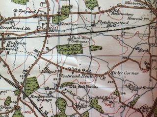
Ordnance Survey Old Series 1831 - 1835
Ordnance Survey Revised New Series 1901 - 1902
Ordnance Survey Popular Edition 1920 - 1921
“Westwood is in the melting pot,” he wrote, ”changing visibly almost each month. It may be compared to an octopus, somewhat lifeless in the centre, with lively tentacles reaching out on all sides. The population exceeds 2,500, and the voters number 1,044. The centre of the village remains as in former years, while all types of houses are built on the borders. One frontage may be a modern motor works, another a row of small dwellings, others a succession of villas in various designs, or a Liliputian garden city. Then comes the inevitable shopping centre, and the appearance of the suburbs of a large town, its sight, supplanting those of the farm roller and the sportsman's gun.”
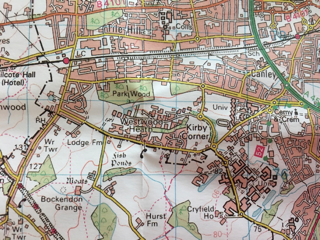
On these maps, from 1831, 1901, 1920 and present day, you can see how the area had slowly developed with the drastic change apparent on the present day map (actually not all recent building is on there!). Perhaps you can spot the place where you now live.
As always, the History Group would love to hear from you with your own memories, photos, questions and suggestions.
Ordnance Survey 1:50,000 mapping data Present Day
Maps:
Images copyright Cassini Publishing Ltd. and used with permission
Sources:
C.F. Neale's article in the Coventry Herald 27th May 1927. Accessed at findmypast.com
Further Reading:
Explore www.burtongreen.blogspot.com


Comments